Background
In recent decades, wildland fires have become a significant hazard. They threaten and kill people, destroy urban and rural property, degrade air quality, ravage forest ecosystems, contribute to global warming, and, overall, have had disastrous consequences from socio-economic and environmental points of view. Effectively combating wildland fires requires both early detection and an understanding of where the fire will spread, so can be quickly contained and extinguished.
Accurate and efficient near-real time wildfire predictions are critical for decision-making about firefighting strategy and short-term fire emergency response as well as longer-term fire risk assessment. However, the ability to forecast/simulate the spread of wildfires is currently limited because of the complexity of fire dynamics and the processes that control it. Wildfire is a multi-scale event ranging from the scale of an individual flame to that of a large fire plume. Wildfire involves interactions between the fuel (vegetation) combustion process and the surrounding atmosphere, terrain, and unburnt vegetation. At present, 3-D (three-dimensional) physics based CFD (Computational Fluid Dynamics) codes have been developed to accurately simulate wildfires. However, these 3-D CFD-based simulations tools require large amounts of processing capabilities and often take hours or days to generate simulation results. With wildfires becoming more prevalent across the country, being able to model, predict, and update models in real-time and provide feedback to firefighters could assist in mitigating damage caused by fires.
Approach
The objective of the targeted IR&D project was to develop a mathematical and numerical framework for a wildfire simulation tool that (1) accounts for all pertinent wildland fire spread mechanisms (i.e., ground level surface spread through live vegetation and dead wood, crown fire initiation and spread, and fire spread through lofting, transport and spotting of firebrands); (2) is capable of predicting wildfire spread with reasonable accuracy and at a rate that is sufficient to make it suitable for use by commanding officers during an incident; (3) can be periodically reset to synchronize the model predictions with satellite data showing the contours of the fire, weather data and observations on the fireground; and (4) can be easily updated as important research results and analyses of actual wildfires become available.
Upon completion of the targeted IR&D project, the plan was to use the results in a proposal to the Assistance to Firefighters Grants (AFG) program of the Department of Homeland Security (DHS) to further develop the framework into a validated user-friendly software package that can be deployed to wildland firefighters throughout the U.S.
The 2022 Rolling Pines fire in Bastrop, Texas was used as the test case for the model. Two wildfire simulation codes, namely FDS (Fire Dynamics Simulator, a CFD code developed at the National Institute of Standards and Technology specifically to simulate fires) and FLAMMAP (a collection of semi-empirical models developed by the United States Department of Agriculture Forest Service) were used for the simulations of the Rolling Pines fire.
Accomplishments
From efforts to use both the physics-based and faster level set models in FDS and the FLAMMAP model to simulate the Rolling Pines Fire, the project team determined that FLAMMAP is the only model that meets the first objective and the second part of the second objective. However, from these fire simulations, the team discovered that fuel moisture is difficult to determine with a reasonable degree of accuracy. The team determined that large uncertainties in the specified fuel moisture content (and other input parameters, for that matter) result in inaccurate predictions (as large as ± 35 percent for the rate of spread), which does not meet the first part of the second objective.
Based on the IR&D work, the project team concluded that the development of a framework for the “ideal” operational model is not realistic. Instead, for a future proposal to NASA and DHS, the investigators intend to focus on the wildfire spread mechanism that involves generation and lofting of burning brands. They aim to develop a deep learning data-driven model based on a detailed analysis of historical fires in which burning brands were a major factor in the growth and damage of the fire and simulations in FDS, similar to work done in Australia. The resulting deep learning model will be coupled with other data driven models to predict surface and crown fire spread rates and deep learning models to determine the fire perimeter from UAV or satellite IR images. This will also allow the team to leverage the Institute’s extensive experience and expertise in machine learning.
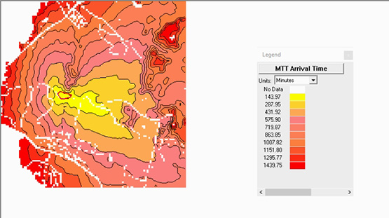
Figure 1: MTT Arrival Time by Minutes.
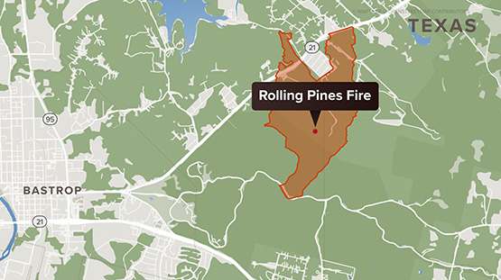
Figure 2: Perimeter of Rolling Pines Fire.